You’ve hit your search limit
Start your free trial to keep exploring full traffic and performance insights.
Get StartedAnálisis de la app Swiss DroneMap para 16 de mayo
Swiss DroneMap
- Benjamin Koch
- App Store de Apple
- Pagado
- Navegación
Shows the relevant informations to fly a drone in Switzerland.
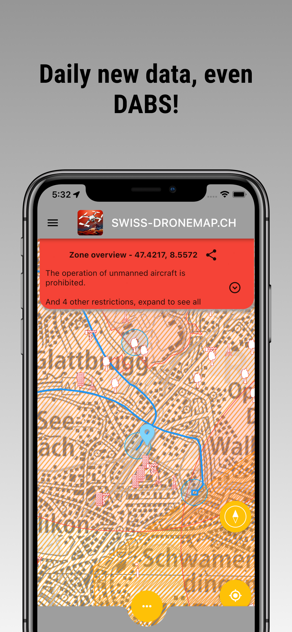
The relevant aviation data get updated each day. DABS data gets updated every hour.
We show you where you can fly and where not.
As a drone pilot, it's essential to know the areas where flying is prohibited or limited to ensure the safety of people and property on the ground, as well as other airspace users such as planes and helicopters. Our map displays all the necessary information about national and cantonal restrictions to help you plan your drone flights accordingly.
With our app, you can also manage all the documents you need, such as the remote pilot certificate, the operator number and the insurance certificate, both for private and for business, so you always have them with you.
National and Cantonal Restrictions: The following restrictions apply in Switzerland:
5km radius around civil or military airfields: Flying a drone in this area is prohibited unless you have explicit permission from the airfield operator or air traffic control.
Control zones CTR: These are designated airspace areas around airports, where drone flying is only allowed under specific conditions and with the approval of air traffic control.
Civil airfield perimeter according to the sectoral plan for aviation infrastructure or military airfield perimeter according to the sectoral plan for the military: Flying a drone within the perimeter of a civil or military airfield is prohibited.
Penal institutions: Flying a drone over or near a prison is prohibited.
Protection areas for wild animals: There are several protected areas in Switzerland, where drone flying is either prohibited or only allowed under specific conditions.
In the vicinity of nuclear power plants: Flying a drone near a nuclear power plant is prohibited.
Over military zones: Flying a drone over military zones is prohibited.
Certain energy and gas supply infrastructure: Flying a drone near specific energy and gas supply infrastructure is prohibited.
Obstacles for aircraft, such as poles, buildings, transmission lines, and other relevant elements: Drone flying is dangerous near any obstacle, plan ahead with our map.
Nature and forest reserves: There are several protected nature and forest reserves in Switzerland, where drone flying is either prohibited or only allowed under specific conditions.
Using our interactive drone map, you can quickly check the relevant area restrictions before each flight and plan accordingly to ensure a safe and enjoyable drone flying experience. Keep in mind that failure to comply with the restrictions could lead to fines or other legal consequences. So, always be sure to follow the rules and fly responsibly. Start exploring our map now and discover the beauty of Switzerland from above while respecting the airspace regulations!
Clasificación de tiendas
El Store Rank se basa en múltiples parámetros establecidos por Google y Apple.
Todas las categorías en
Estados Unidos--
Navegación en
Estados Unidos--
Principales competidores & aplicaciones alternativas
Aplicaciones con una alta probabilidad de ser utilizadas por los mismos usuarios, desde la misma tienda.
SkyGuard for Drones
Swiss3D Pro
Stadt Burgdorf
Basler Bus & Tram
mayo 16, 2026