You’ve hit your search limit
Start your free trial to keep exploring full traffic and performance insights.
Get StartedGPS Land Measurement & Survey app analytics for January 28
GPS Land Measurement & Survey
- LOGISIAN TECHNOLOGY SOLUTIONS PRIVATE LIMITED
- Apple App Store
- Free
- Utilities
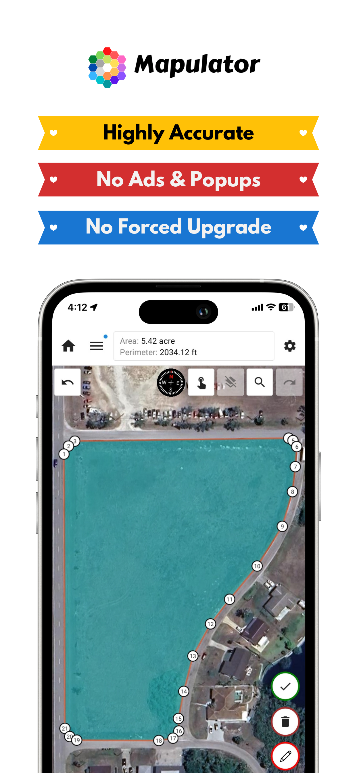
GPS Area Measure - Mapulator is a powerful measurement app for iPhone designed for professionals and individuals who need field area measurements, GPS measure distance, and land surveying tools. Whether you're working in land survey, property lines mapping, fieldmaps, or need a distance calculator for land navigation, this app provides quick and accurate results.
Accurate GPS-Based Land and Distance Measurement
Turn your iPhone into a digital tape measure and map maker with precise area measurement, radius map, and measure angles capabilities. Ideal for roof, room measurements, and land measurement calculations, Mapulator helps you get the most out of your measurements.
Key Features:
• Multiple Measurement Tools – Measure land area, perimeter, distance, and radius map with precision.
• GPS Live Mode – Walk or move to measure distance in real time.
• Multiple Units Supported – Work with meters, acres, hectares, and more.
• Customizable Maps – Use land maps, field maps, and terrain views for better accuracy.
• Advanced Calculation Tools – Includes an area calculator, measurement calculator, and measure angles tool.
• Undo/Redo Feature – Easily correct measurements without restarting.
• Search & Export – Find locations quickly and export data in KML or GeoJSON.
• Offline Support – Access field area measure tools even without an internet connection.
Why Choose Mapulator?
• Highly Accurate GPS Measure Distance – Get reliable land surveying results.
• User-Friendly Interface – Easy to use for professionals and beginners.
• Versatile Application – Ideal for roof measure, room measurement, property lines mapping, and more.
• Free Measuring App Features – Access essential tools in the measure-free version.
Who Can Benefit?
• Surveyors & Engineers – Conduct land surveying with field area measure accuracy.
• Farmers & Landowners – Use land map tools to measure and calculate property lines.
• Construction Professionals – Plan projects with a measurement calculator for roof and room measurement.
• Outdoor Enthusiasts – Navigate with land navigation and GPS measure distance features.
Welcome to GPS Area Measure by Mapulator! We're an ecstatic mapping tool for precise area, perimeter, and distance calculations. Whether you're a seasoned professional or just exploring your surroundings, Mapulator empowers you with accurate measurements at your fingertips.
Dive into a world of seamless mapping and precise calculations. Explore our intuitive interface and discover the power of real-time GPS measurement, customizable map views, and versatile measurement tools. From land surveying and agricultural planning to construction management and outdoor adventures, Mapulator is your trusted companion for all your measurement needs.
How to Use the App?
1. Select a Measurement Tool – Choose from area measure, measure distance, or radius map.
2. Mark Points on the Map – Use the interactive map maker to outline areas.
3. Customize Settings – Adjust map layers for field map visualization.
4. Enable GPS Live Mode – Measure distance tracking on the go with GPS.
5. Save & Export – Store and share your land map and measurements.
Accurately measure areas, perimeters, and distances on maps with GPS Area Measure by Mapulator. Perfect for land measurement, agriculture, surveying, construction, and more.
Precise Mapping Tool for Professionals & Enthusiasts
Mapulator is the ultimate mapping tool for professionals and enthusiasts. Whether you're a land surveyor, real estate agent, farmer, construction manager, or simply curious about your surroundings, Mapulator provides the precision and flexibility you need. Easily calculate areas, distances, and radii directly on the map, transforming your mobile device into a powerful measurement instrument.
Download Now
Get GPS Area Measure - Mapulator, the free measuring app that simplifies land surveying, distance calculations, and area measurements for iPhone users.
Store Rank
The Store Rank is based on multiple parameters set by Google and Apple.
All Categories in
United States--
Utilities in
United States--
Top Competitors & Alternative Apps
Apps with a high probability of being used by the same users, from the same store.
Map Area Calculator - Marea
Property Survey GPS
Measure Map Pro
Distance Tool
January 28, 2026