You’ve hit your search limit
Start your free trial to keep exploring full traffic and performance insights.
Get StartedAnálisis de la app Dronetag para 1 de abril
Dronetag
- Dronetag
- Google Play Store
- Gratis
- Herramientas
With Dronetag, all drones fly safe & compliant. Our app helps everyone to receive and read drone identification data and offers a wide range of professional features to owners of Dronetag remote identification devices. We create a world where all drones can access airspace without the need to worry about accidents.
Dronetag Mini and Dronetag Beacon are add-on devices for remote identification designed and manufactured by us. They can be attached to any drone, making it digitally visible via Remote ID standards to all air traffic participants.
- Dronetag Mini -
Weighs 32 grams, offers up to 14-hour battery life, and supports both Direct & Network Remote ID technologies (DRI & NRI) via Bluetooth and LTE.
- Dronetag Beacon -
Weighs only 16 grams, offers up to 16-hour battery life, and supports Direct Remote ID technology (DRI only) via Bluetooth broadcasting.
Connect your device to the Dronetag app and enjoy the following features:
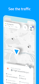
- Airspace scanner displaying all participants with Remote ID (available even without Dronetag device)
- Remote identification for your drone compliant with EU & US regulations
- Option to add and manage an unlimited number of unmanned aircraft
- Map of restricted zones such as airports within the whole EU & US
- Flight planning, including the time and altitude
- Flight tracker with a real-time position on the map and notifications
- Journal feature to save and export flight data of all your drones
- Full-text search: locations, restricted zones, aircraft, and Dronetag devices
Connect with the Dronetag team
Let’s chat about drones, flying, and tech. Send us your feedback or questions to: support@dronetag.cz
Clasificación del uso de Dronetag
El rango de uso se basa en el algoritmo de Similarweb que calcula las instalaciones actuales y los usuarios activos durante un periodo de 28 días.
Todas las categorías en
Estados Unidos--
Herramientas en
Estados Unidos#8,378
Intereses de los usuarios & Top categorias
Principales categorías y aplicaciones utilizadas por los usuarios de Dronetag.
Categorías principales
Afinidad
Principales aplicaciones de la categoría
24%
20%
17%
10%
Principales competidores & aplicaciones alternativas
Aplicaciones con una alta probabilidad de ser utilizadas por los mismos usuarios, desde la misma tienda.
ZUMIMALL
ABAX Admin
BaseMap: Hunting Maps and GPS
Spoked: AI Cycling Coach
abril 1, 2026