Drone Scanner app analytics for March 24
Drone Scanner
- Dronetag
- Google Play Store
- Free
- Tools
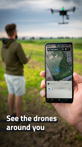
Transform your phone or tablet into a drone scanner and track all the nearby flights over Direct / Broadcast Remote ID standards. Browse real-time data about drones on a detailed map highlighting specific flying space zones. Download Drone Scanner for free and discover what drones fly above your head.
Favourite features:
- Discover more about drones flying nearby in real-time
- Examine detailed information broadcasted by drones via Bluetooth 4, Bluetooth 5, Wi-Fi Beacon, and Wi-Fi NAN
- Browse a detailed map with your location and all nearby aircraft
- Check available data about drones, including real-time height, direction, pilot identification, pilot position, operation description, and location history
- Various flying zones marked and highlighted on the map
- Easy export of collected data
- Continuously updated to reflect the latest EU & US regulations
All these features you find in Drone Scanner – a free app for tracking drones. The app is developed by Dronetag company manufacturing devices for drone remote identification.
How it works
Anyone can quickly identify what drones are flying in the sky nearby. Direct Remote ID is a feature that transmits live flight data via Bluetooth or Wi-Fi to the surrounding area. Drone manufacturers use various technologies to build an identification feature in new drones. Pilots of older drones are using add-on devices, enabling them to become digitally visible. With hardware on your smartphone, Drone Scanner can receive and read broadcasted data.
Drone Scanner Usage Rank
The usage rank is based on Similarweb's algorithm that calculates current installs and active users over a 28-day period.
All Categories in
United States--
Tools in
United States#3,472
Users Interests & Top Categories
Top categories and apps used by Drone Scanner users
Top categories
Affinity
Top apps within the category
More apps
19%
13%
12%
9%
Top Competitors & Alternative Apps
Apps with a high probability of being used by the same users, from the same store.
KrakenSDR RDF
MarineTraffic - Ship Tracking
Mobile Security Camera (FTP)
Fleetio Go - Fleet Management
March 24, 2025