TUSantander app analytics for March 18
TUSantander
- Ayuntamiento de Santander
- Google Play Store
- Free
- Maps & Navigation
The Santander City Council launches this application to support users of the city's Public Transport Network.
Designed for both the Android and IOS systems, the configuration of the screens has been developed so that navigation through them is accessible to any type of user intuitively.
Through this application, the user will have accurate and up-to-date information on the public transport offer in the city (operating transport lines, travel times, etc.), they will be able to know in real time the timetables of the buses by stop and line and you will have a route planner that will allow you to optimize the travel time between an origin and a specific destination.
In summary, the user will have access to:
• Lines.
The system displays the list of all operating lines.
The user can immediately have the estimation of the passing times of the buses of the different lines for a specific stop or the passing times of the buses of a specific line.
You also have access to the information regarding the departure times of the headers of each of the lines.
• Routes and scheduled times
By selecting a specific date (the same or different from the current date), the application enables the user to have information on timetables for stops.
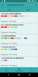
• Nearest stops.
The application shows on the screen a map showing the stops closest to the point of the city where the user is located and the list of these stops (requires having the terminal's gps activated).
• Close balance recharge points.
The application shows on the screen the list of points of recharge of balance / sale of transport cards closest to the point of the city where the user is (requires having activated the gps of the terminal).
• Route planner
The application provides access to a route planner through which the user can determine the optimal trips to be made between a specific origin and destination (stops) of the city's public transport network.
• Rates
The application shows information regarding current transport rates in all its forms.
• Lost objects
The application shows information on lost objects by users of the Public Transport Network who are in the custody of YOUR.
• About YOUR
The user has information from the TUS Service (contacts, phone numbers, email, etc.).
Icons work of Freepik , SimpleIcon and Smashicons obtained at www.flaticon.com
TUSantander Usage Rank
The usage rank is based on Similarweb's algorithm that calculates current installs and active users over a 28-day period.
All Categories in
United States--
Maps & Navigation in
United States--
Top Competitors & Alternative Apps
Apps with a high probability of being used by the same users, from the same store.
Athens Metro Guide and Planner
Taximeter
Lisbon Metro Guide & Planner
Valencia Metro Guide & Planner
March 18, 2025