23 Martiçin Hunterra: My hunting map uygulama analizi
Hunterra: My hunting map
- HUNTERRA, s. r. o.
- Google Play Store
- BOŞTA
- Haritalar ve Navigasyon
Hunterra, the European hunters' choice number 1, was developed based on the needs of the hunting community, in collaboration with leading figures in Czech hunting, under the guidance of experts from the first accredited European university program focused on hunting.
Hunterra is designed to support the Central European game management system, the Scandinavian licensing system, as well as other systems based on land ownership or licenses.
Features for individual hunting include:
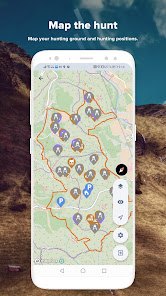
- Creating and editing hunting maps directly in the field (including boundaries, lines, and points of interest) and sharing them with selected users.
- Recording routes (e.g., to plot game trails, wildlife paths, and slopes).
- Displaying current location, navigating to points of interest, and easily showing their distances.
- Reservation system for stands and other facilities in the hunting ground.
- Hunting ground visitor logbook.
- Detailed and up-to-date base maps.
- Ability to download maps offline to the phone in case of insufficient data connection in the field.
- Keeping legal hunting records.
- Electronic documentation of permits, licenses, and permissions.
- Reliable weather forecast, including an active wind direction indicator.
- Support for displaying photos from game cameras.
- Notifications about events in the hunting ground.
The Hunterra platform allows the organization of joint hunts at a professional level. Organizers who are considered the best in organizing joint hunts in the Czech Republic have shared their experiences with us. Hunterra provides an opportunity to impress hunting guests with a perfect course of the hunt while increasing the safety of participants.
Features for joint hunts include:
- Easy setup of a hunting event and its offering to hunting guests.
- Sharing the location and movement of all participants in real-time.
- Sharing the movement of hunting dogs with participants in real-time (supporting Garmin and Dogtrace).
- Informing participants about the progress of the hunt directly in the application (start of tracking, end of tracking, etc.).
- Marking downed or injured game on the map to facilitate tracking and retrieval by hunting personnel.
- Displaying the course of the hunt after its completion.
Other mapping features include:
- Distance and area measurement.
- Distance circles (dynamic or with a defined distance - e.g., MRD).
- Displaying location information on the map.
- Perfect overlay maps with vegetation, cadastral, and hunting information.
Through the event creation and management features, it is possible to offer individual hunts or participation in joint hunts to the hunting community. Viewing hunting offers based on specified parameters has never been easier. The application's controls are based on standard applications (Apple Maps, Calendar), and the user interface and settings remain clear and easily accessible.
Hunterra: My hunting map kullanım sırası
Kullanım sıralaması, Similarweb'in 28 günlük bir süre boyunca mevcut yüklemeleri ve aktif kullanıcıları hesaplayan algoritmasına dayanmaktadır.
Tüm kategoriler içinde
Almanya--
Haritalar ve Navigasyon içinde
Almanya--
En İyi Rakipler & Alternatif Uygulamalar
Aynı mağazadan, aynı kullanıcılar tarafından kullanılma olasılığı yüksek olan uygulamalar.
Skill: Ski & MTB Tracker
Orca: Boat GPS, Charts, Routes
Seabook: Fish identifier
Fishbuddy by Fiskher
Mart 23, 2025