BaseMap: Hunting Maps and GPS app analytics for 20 de março
BaseMap: Hunting Maps and GPS
- BaseMap Inc
- Google Play Store
- Gratuitos
- Esportes
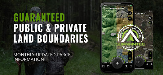
Guaranteed land ownership maps, mobile hunt planner with draw odds, industry leading GPS tools for hunters and outdoorsmen.
OFFLINE GPS and TRACKING
• Cache maps for offline use without service
• Save as many offline maps as you want with unlimited caching (Pro)
• Know exactly where you are in real time even without cellular coverage
MAP LAYERS
• Over 800 layers and growing
• Nationwide Color Coded Govt Lands
• Nationwide Private Parcel Boundaries & Owner Names
• Water depths for East coast, West, Coast, Gulf coast, & over 4,000 U.S. lakes
• Nationwide Hiking Trails
• Nationwide Wildfires & Timber cuts
• Nationwide Wilderness & Roadless Areas
• State specific hunting layers including hunting unit boundaries, private hunting opportunities, WMA’s & more
• Multiple Topography & Satellite Imagery basemap options
• Much more
MOBILE HUNT PLANNER
• Unit filtering
• Draw odds
• Harvest data
• Season dates
• Unit insights
LRF MAPPING (Laser Rangefinder Mapping)
• Use your rangefinder as a powerful mapping tool
• Precisely mark the exact location of distant targets with ANY rangefinder
• Recover game, build routes, plan stalks, lookup distant property owners and more, all using your rangefinder!
MOBILE GPS
• Know your exact location even without cellular or WiFi service
• See where you are in relation to property boundaries, roads, trails, peaks, or boundaries
• Navigate to trail heads, favorite places, markers, or anything you need to locate with our powerful Search and GoTo features.
XDR (Exact Direction & Range) NAVIGATION TOOL
• Easy Point and Go navigation
• Know the exact distance between you and your destination.
HUNTWIND™ & WEATHER CENTER
• Wind forecast to better plan your hunt.
• Know the exact day and time to hunt a particular stand and visualize wind direction and scent drift in relation to your location.
• Forecasts, temperature, moon phase, sunrise/sunset, wind, and more.
LOCATION SHARING
• Know exactly where your hunting partner is located
• Real-time updates
OUTDOOR JOURNAL
• Capture, log, and share all your outdoor adventures with the BaseMap community
• Real-time location sharing so friends can see where you are in case of emergency (connection reqd.)
• SmartMarkers - Automatically capture the weather conditions at the time you add a marker.
HARVEST LOG
• Log your hunts as detailed as you'd like. Record your hunt type, species/size, weapon, unit/GMU & much more.
•
GOOGLE EARTH INTEGRATION
• Export markers and view them right in Google Earth
• View the terrain in true 3D
DESKTOP APPLICATION
• Automatically sync all your data between your phone and the BaseMap web application.
SUBSCRIPTIONS
BASIC (Free)
• No Ads
• Connect with friends
• Hybrid 3D Imagery (map tilt).
• XDR Navigation
• Nationwide Roads, Trails & Points of Interest
• Nationwide Lakes, Rivers & Streams
• Hunting Unit boundaries
• GPS Location & Tracking
• Hi-Res Satellite Imagery
PRO ($39.99/yr)
• Everything in Basic plan
• Access to over 800 Layers
• Unlimited Data & Offline Use
• Nationwide parcel boundaries and owner names
• Nationwide color-coded government lands
• Google Earth Integration
• Import/Export KML and GPX with BaseMap web application
• Real-Time location sharing
• LRF Mapping (Laser Rangefinder Mapping)
PRO ADVANTAGE ($69.99/yr)
• Includes:
• BaseMap Pro subscription
• Global Rescue subscription for field advisory and rescue services
PRO ULTIMATE ($99.99/yr)
Includes:
• BaseMap Pro subscription
• Global Rescue subscription for field advisory and rescue services
• Mobile Hunt Planner tools: Unit filtering, draw odds, harvest data, season dates, and more
For questions or more information, contact us at: support@basemap.com
Privacy policy: https://www.basemap.com/privacy-policy/
Terms of use: https://www.basemap.com/terms-of-use/
Government Information: BaseMap Inc does not represent any government entity. You may find various links to public information within our data.
Sources: https://data.fs.usda.gov/geodata/
BaseMap: Hunting Maps and GPS classificação de uso
A classificação de uso é baseada no algoritmo da Similarweb que calcula as instalações atuais e os usuários ativos ao longo de um período de 28 dias.
Todas as categorias em
Estados Unidos--
Esportes em
Estados Unidos#508
Interesses dos Usuários e Principais Categorias
Principais categorias e aplicativos usados pelos usuários do BaseMap: Hunting Maps and GPS
Principais Categorias
Afinidade
Principais Aplicativos Dentro da Categoria
Mais aplicativos
17%
14%
14%
11%
Principais concorrentes e aplicativos alternativos
Aplicativos com alta probabilidade de serem usados pelos mesmos usuários, da mesma loja.
onX Hunt: Offline Hunting Maps
onX Offroad: Trail Maps & GPS
PeakVisor - 3D Maps & Peaks ID
TwoNav Premium: Maps & Routes
março 20, 2025