Handy GPS lite app analytics for 21 marzo
Handy GPS lite
- BinaryEarth
- Google Play Store
- Gratis
- Mappe e navigazione
The perfect companion for your next outdoor adventure. Seek, find, record and return home with Handy GPS. No user account or setup required - just install it, turn on your GPS and go!
This app is a powerful navigation tool designed for outdoors sports like hiking, bushwalking, tramping, mountain biking, kayaking, horse trail riding, and geocaching. Its also useful for surveying, mining, archaeology, and forestry applications. Its simple to use and works even in the remotest back country since it doesn't require network connectivity. It allows you to work in UTM or lat/lon coordinates so you can even use it with your paper topographic maps.
NOTE: This is a free trial version and is limited to storing only 3 waypoints, and 40 track log points. You can use the trial version for as long as you want, but if you like this app, please install the paid version of "Handy GPS" to get an unlimited version with lots more features. Thanks!
Also, allow the app to always use GPS, and turn off battery optimisation for the app to reliably record tracklogs when the phone screen is off.
BASE FEATURES:
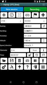
* Shows your current coordinates, altitude, speed, direction of travel, and total distance travelled in metric, imperial/US, or nautical units.
* Can store your current location as a waypoint, and record a track log to show where you've been on a map.
* Data can be imported from and exported to KML and GPX files.
* Allows manual entry of waypoints in UTM, MGRS and lat/lon coords.
* Can guide you to a waypoint using the "Goto" screen, and optionally sound an alert when when you're getting close.
* Has a compass page which works on devices with magnetic field sensors.
* Automatically computes the local geoid offset to improve altitude accuracy
* Supports the world-wide WGS84 datum along with the common Australian datums and map grids. You can use WGS84 for NAD83 maps in the US.
* Shows GPS satellite locations and signal strengths graphically.
* Can display simple or MGRS grid references.
* Can compute waypoint-to-waypoint distance and direction.
* Includes an optional timer line to record walk duration and compute your average speed.
* Thoroughly tested by the developer on many off-track walks
EXTRA FEATURES ONLY IN THE PAID VERSION:
* No ads.
* An unlimited number of waypoints and track log points.
* Offline maps.
* Custom datums.
* Elevation profile.
* Take photos and record voice memos from the app.
* Email or SMS your location to a friend.
* UK grid refs.
* GPS averaging to improve location accuracy,
* Sun rise and set times.
* Export waypoints and tracklogs to a CSV file.
* Project waypoints using bearing and distance.
* Compute length, area, and elevation change from the tracklog.
* Compute calories.
PERMISSIONS: (1) GPS - to determine your location, (2) Network access - for access to standard map layers and OSM tiles, (3) SD card access - to load and store waypoints and tracklogs, (4) Camera access for taking pics*, (5) Prevent phone from sleeping so that proximity alarm works, (6) Control flashlight, to allow the flashlight to be turned on/off from within the app, (7) Record audio for voice memos*. (* Feature only available in full version of app).
DISCLAIMER: You use this app at your own risk. The developer accepts no responsibility for you getting lost or injured as a result of using this app. Batteries in mobile devices can go flat. For extended and remote hikes, a battery bank and an alternative method of navigation such as a paper map and compass are recommended for safety.
Ranking di utilizzo di Handy GPS lite
Il ranking di utilizzo si basa sull'algoritmo di Similarweb che calcola le installazioni correnti e gli utenti attivi su un periodo di 28 giorni.
Tutte le categorie in
Stati Uniti--
Mappe e navigazione in
Stati Uniti--
Principali concorrenti e app alternative
App con un'alta probabilità di essere utilizzate dagli stessi utenti, provenienti dallo stesso store.
Avenza Maps: Offline Mapping
Nautide: Tides, Wind, Waves +
Gaia GPS: Offroad Hiking Maps
VesselFinder
marzo 21, 2025